
|

|
|

|

|
|
|

|

|
|
|
|
|
|
|
|
|
SDG 15.2.1 Events about sustainable use of land
In addition to sustainable land use, National Changhua University of Education (NCUE) is involved in various other projects or activities, including the Department of Biology’s “Taoyuan International Airport Corporation Program/ Commissioned Planning and Design for Invasive Red Fire Ant Control Operations”, Department of Geography’s “Monitoring of Agro–Fishing Socio-Ecological Systems in the Coastal Wetlands of Western Taiwan(3/3)” and “From Knowledge Gaps to Sustainable Groundwater Action Plans: Disaster Risk Communication and Value Construction in the Land Subsidence Areas of Changhua”, summarized in the following Table 1. The following section contains project descriptions.
Table 1. Related projects and events
|
Project Name |
Funding Agency |
|
Taoyuan International Airport Corporation Program/ Commissioned Planning and Design for Invasive Red Fire Ant Control Operations |
Taoyuan International Airport Corporation |
|
Monitoring of Agro–Fishing Socio-Ecological Systems in the Coastal Wetlands of Western Taiwan (3/3) |
National Science and Technology Council |
|
Climate Resilience Development and Disaster Adaptation Governance: A Participatory Approach with Just Transition — Subproject III “From Knowledge Gaps to Sustainable Groundwater Action Plans: Disaster Risk Communication and Value Construction in the Land Subsidence Areas of Changhua” |
National Science and Technology Council |
NCUE’s relevant projects included:
1. Commissioned Planning and Design for Invasive Red Fire Ant Control Operations
In order to protect navigational and public facilities in the airport area, uphold the nation’s image, and reduce fire ant attacks on airport staff and travelers, monitoring and controlling invasive of red fire ants at Taoyuan International Airport are a must, and we must remain vigilant until their eradication in the Dayuan District. This project aims to continue red fire ant control across the airport, where operations must comply with strict aviation safety rules and adjust accordingly to different weather conditions. Tasks such as manpower planning, field monitoring, treatment planning and execution require a team equipped with both red fire ant control expertise and airport-specific experience (Figure 1).
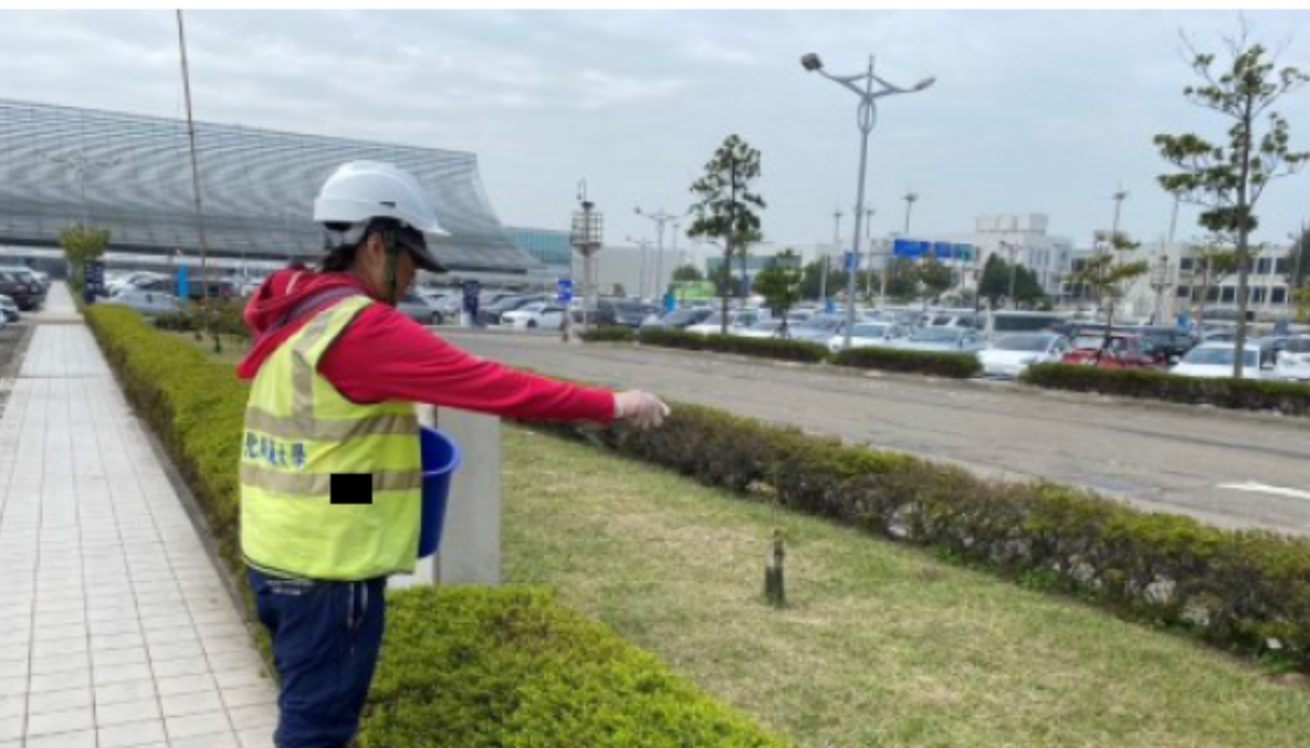
Figure 1. Carrying out pest control operations in the terminal parking lot.
2. Monitoring of Agro–Fishing Socio-Ecological Systems in the Coastal Wetlands of Western Taiwan
The Department of Geography at NCUE is undertaken the National Science and Technology Council (NSTC) project “Monitoring of Agro–Fishing Socio-Ecological Systems in the Coastal Wetlands of Western Taiwan (3/3).” Fangyuan was designated as the core observation site to establish a place-based demonstrative observation program. This initiative implements long-term, fundamental, and critical monitoring of core socio-ecological system components, serving as the central hub within the Long-Term Socio-Ecological Research (LTSER) network in Changhua.
Field investigations at the station encompass water quality assessments, ecological surveys, and geomorphological monitoring in the Fangyuan, Hanbao, and Wanggong wetlands. A complete year of baseline surveys was accomplished in 2024, and continuous monitoring will be maintained in subsequent years. In-depth interviews with key local stakeholders constitute a vital element of the station’s social research, which strengthened the LTSER platform’s local engagement network. These interviews were systematically documented and analyzed stakeholder roles, functions, and relationships of stakeholders, as well as their experiences and observations of socio-ecological transformations, thus providing a robust social–ecological data foundation for the platform.
Drawing upon insights from these interviews and local documentary sources, the station developed questionnaires to further assess residents’ opinions on environmental and renewable energy issues. Station staff also actively participate in local gatherings to identify emerging concerns and develop collaborative opportunities with community partners. The long-term monitoring program aims not only to advance scientific understanding but also to address locally relevant needs. See Figure 2 for relevant activities.
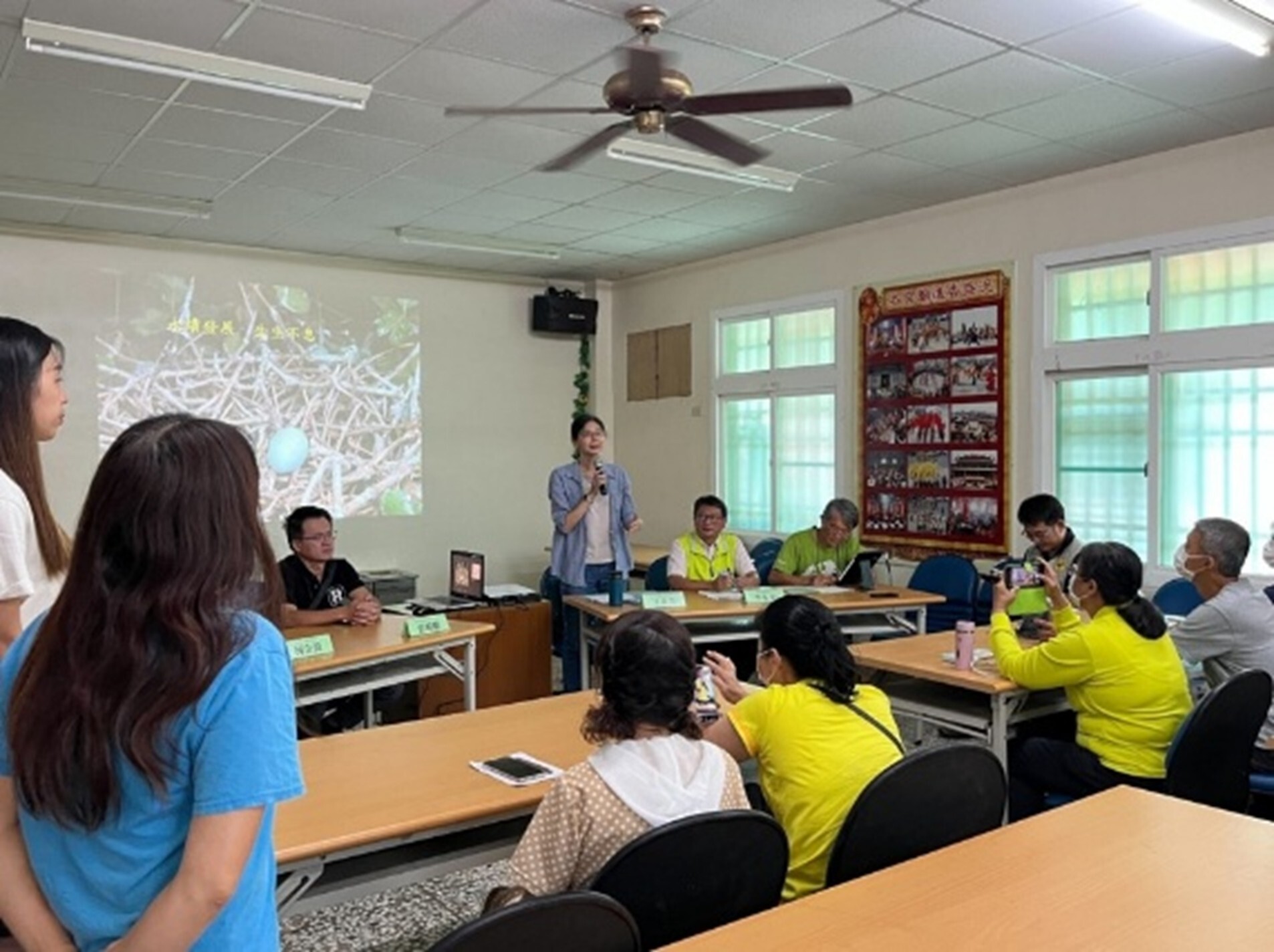
Figure 2. Attendance at the Symposium on Coastal Wetland Conservation in Changhua
3. From Knowledge Gaps to Sustainable Groundwater Action Plans: Disaster Risk Communication and Value Construction in the Land Subsidence Areas of Changhua
The project originally focused on filling knowledge gaps and facilitating risk communication surrounding land subsidence disasters, with the aim of establishing local development values aligned with the principles of a just transition. In recent years, however, with the growing scale of renewable energy development under increasing pressure from the climate crisis, the research has shifted to examine issues of just transition related to the installation of solar and wind power facilities in the Fangyuan and Dacheng areas of Changhua. To date, ten local stakeholders—including village leaders, landowners, farmers, residents, and solar energy developers—have been interviewed, with the fieldwork still ongoing. Through qualitative interviews, the project seeks to identify knowledge gaps and shortcomings in risk communication, while attempting to propose potential solutions.