
|
|

|

|

|
|
|

|

|
|
|
|
|
|
|

|

|
SDG 13.3.4 Inform and support government
1. NCUE’s faculty members actively participate in various research and practical projects, addressing the challenges brought by global warming, providing concrete suggestions, and supporting relevant planning and management for local or regional governments. As shown in Table 1, Professor Jien-yi Tu conducted in-depth research on the “Impacts of Large-scale Circulation Changes on Precipitation in the Asian Monsoon Region under Global Warming”, providing scientific basis for future climate adaptation and water resource management.
Furthermore, the Department of Fine Arts USR project "Ecological Homelands and Urban-Rural Sustainability" promotes campus green surveys and organizes faculty community horticultural therapy workshops through inter-level campus collaboration, cultivating students' ability to observe climate and environmental changes; organizing lectures and observation activities related to grey-faced buzzards and purple crow butterflies to strengthen understanding of species migration and habitat changes; and implementing street green surveys and urban heat island effect observations, transforming them into ecological art exhibitions. These actions gradually establish community foundations for local climate risk perception and monitoring.
Concurrently, Professor Chuian-fu Ken from our university has been promoting the "Beautiful and Treasured Clams in Fangyuan and Dacheng: Sustainable Industry and Environment Project of Changhua’s Two Cities Amid Climate Change" project. This initiative assisted local governments in facing climate change challenges, encompassing environmental education, raising air pollution awareness, wetland conservation, and more. Through interdisciplinary collaboration and the promotion of green energy technologies, the project fostered sustainable development of local industries and the environment, supporting local government efforts in climate change risk management.
Table 1. Serial No., Principal Investigator, Project Title
|
No. |
Project Leader |
Project Name |
|
1 |
Professor Jien-Yi Tu |
Impacts of Large-scale Circulation Changes on Precipitation in the Asian Monsoon Region under Global Warming (III) |
|
2 |
Associate Professor Yi-ching Chen |
Changing Changhua Coastal Landscapes: Artificial Object-Driven Cross-Scale Spatial Development and Social-Ecological System Analysis--Multi-scale Remote Sensing Technology for Observing Changhua Coastal Topographic Changes and Environmental Control Factors (III) |
|
3 |
Professor Su-fen Wang |
Taiwan Western Coastal Wetland Agricultural and Fisheries Social-Ecological System Monitoring |
|
4 |
Associate Professor Man-ping Wang |
University Social Responsibility Implementation Project: “Ecological Homelands and Urban-Rural Sustainability: A Changhua Ecological Art Project” |
|
5 |
Professor Chuian-fu Ken |
“Beautiful and Treasured Clams in Fangyuan and Dacheng: Sustainable Industry and Environment Project of Changhua’s Two Cities Amid Climate Change" project |
2. Project content descriptions are as follows:
(1) Professor Jien-yi Tu, NCUE / National Science and Technology Council Project / Impacts of Large-scale Circulation Changes on Precipitation in the Asian Monsoon Region under Global Warming (III).
(a) Government Research Information System: https://www.grb.gov.tw/search/planDetail?id=16551737
(b) This year's project, part of the results focused on research regarding typhoon-monsoon interactions. The South China Sea, located southwest of Taiwan, falls within the Asian monsoon region. Typhoons formed in this sea area often bring abundant moisture to Taiwan, the Indochina Peninsula, and China's southeastern coast, increasing rainfall amounts. Between 1979 and 2023, the frequency of tropical cyclone (TC) activity in the South China Sea (SCS) during autumn (September to November) showed distinct interdecadal variation characteristics around 2000, with fewer occurrences in the later period. This is related to the decreased number of tropical cyclones generated within the South China Sea itself and the reduced number of tropical cyclones moving from the Western North Pacific (WNP) into the South China Sea. Through data analysis, it was also discovered that low-level anticyclonic anomalies extending from the Bay of Bengal through the South China Sea to the tropical Western North Pacific effectively suppressed tropical cyclone formation and subsequent movement frequency in the South China Sea and tropical Western North Pacific, potentially serving as the cause regulating South China Sea tropical cyclone activity frequency variations on interdecadal timescales(Figures 1-2).
(c) Professor Tu also participated in writing the scientific report jointly published by the National Science and Technology Council and the Ministry of Environment - National Climate Change Science Report 2024. Report content URL:
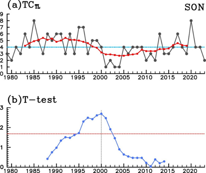
Figure1. (a) Annual and interdecadal (9-year moving average) time series of total tropical cyclones (TC) generated in the South China Sea during autumn from 1979 to 2023. The long-term average of this time series is 4.1 (indicated by horizontal line). (b) t-values of mean difference between two interdecadal periods before and after each year from 1988 to 2014. If a year's t-statistic exceeds 1.68 (marked by horizontal line), the difference between the two interdecadal periods bounded by that year is statistically significant at the 0.05 level
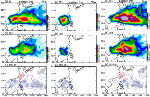
Figure2. Mean values of autumn total tropical cyclone (TC) passage frequency: (a) ID1 (1979-1999), (b) ID2 (2000-2023), and (c) their difference (ID2-ID1). In (c), areas with statistical significance above 0.1 level are shaded. Contour intervals in (a), (b), and (c) are all 0.5. Left panel shows total passage frequency, middle panel shows typhoons generated only in the South China Sea, right panel shows typhoons generated only in the Northwest Pacific
(2) Associate Professor Yi-ching Chen, Department of Geography, NCUE / Changing Changhua Coastal Landscapes: Artificial Object-Driven Cross-Scale Spatial Development and Social-Ecological System Analysis--Multi-scale Remote Sensing Technology for Observing Changhua Coastal Topographic Changes and Environmental Control Factors (III)
(a) Government Research Information System: https://www.grb.gov.tw/search/planDetail?id=16727418
(b) Changhua tidal flat topographic changes serve as an important foundation for studying coastal social-ecological systems, particularly medium- to long-term coastal monitoring. Clarifying the relationships between tidal flat topography and river and coastal geomorphological processes is crucial for understanding the impacts of natural forces, human activities, and climate change. This project utilized multi-scale remote sensing technology to observe Changhua coastal tidal flat topographic changes from 2001-2023, reconstructing medium- to long-term topographic changes using satellite imagery and combining UAV photogrammetry technology to produce high-resolution orthoimages and digital terrain models for observing micro-topographic changes in tidal flats and their relationships with artificial structures. The second-year research proposed an innovative MNDWI+LGM method that can produce more detailed tidal flat topography than traditional shoreline methods. Analysis results show that Changhua tidal flat coasts exhibit distinct seasonal variations: overall erosion occurs during the winter half-year, while deposition occurs during the summer half-year. The movement pattern of north-south barrier islands outside the tidal flats involves north-south accretion and inland migration, with particularly evident siltation phenomena from 2019-2023, including overall topographic elevation accumulation of approximately +0.6 meters in both barrier islands and inner lowlands.
Sediment discharge analysis indicates that Zhuoshui River sediment transport did not decrease due to the Chi-Chi Weir from 1987-2023; instead, it increased following the 1999 Chi-Chi earthquake, but showed no significant relationship with Changhua coastal topographic changes. In contrast, annual variations in Dadu River sediment discharge were more closely related to Changhua tidal flat topography, indicating that coastal littoral drift in Changhua tidal flats primarily originates from the northern Dadu River. Grain size analysis showed that the 2023 typhoon events caused a reduction in average sand grain size in tidal flats, particularly evident north of the Fangyuan crab trails. UAV photogrammetry produced centimeter-level orthoimages and digital elevation models, revealing that topography north of the crab trails was approximately 5-10 cm higher than the south side, confirming the influence of artificial structures on tidal flat micro-topography. The results of this sub-project are integrated with the main project "The Changing Coastal Landscape in Changhua: Objects Driving Cross-scale Spatial Development and Social Ecological System Analysis" to assess the impacts of artificial objects and climate change on Changhua's social-ecological (Figures3-4).
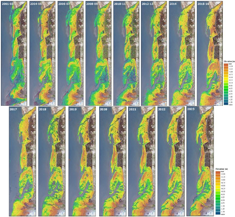
Figure 3. Construction of Changhua Coastal Tidal Flat Topographic Changes from 2001-2023
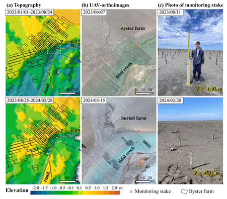
Figure 4. Impact of Hanbo Tidal Flat Topographic Changes on Oysters
(3) Professor Su-fen Wang, Department of Geography, NCUE / Taiwan Western Coastal Wetland Agricultural and Fisheries Social-Ecological System Monitoring
(a) Government Research Information System:
i. https://www.grb.gov.tw/search/planDetail?id=15634481
ii. https://www.grb.gov.tw/search/planDetail?id=17132541
(b) The project aims to establish long-term ecological observation core data for the semi-agricultural and semi-fisheries social-ecological system in Taiwan's southwestern coastal areas, selecting Fangyuan as the observation core to establish locally-based demonstration observation research, providing baseline data for long-term social-ecological system changes and understanding the impacts of related green energy policies on coastal social-ecological systems. Through the Press-Pulse Dynamics (PPD) framework to identify key monitoring indicator items, the long-term social-ecological changes and human-environment interactions can be understood.
(c) Establishment of Long-term Social-ecological Core Observation Changhua Station
The observation station conducts water quality, ecological, and topo graphic surveys at Fangyuan Wetland, Hanbao Wetland, and Wanggong Wetland. The complete annual survey was completed in 2024, with continuous monitoring planned for the future. In-depth interviews with key local stakeholders constitute an important component of social and cultural data in the observation station's social surveys, helping to expand the platform's local social networks. Information regarding different roles, functions, and stakeholder relationships, as well as their experiences and observations of local social and ecological complex changes, is systematically organized and collected, forming an important social-ecological data foundation for the LTSER platform. The observation station designs questionnaires through in-depth interviews and local literature to further understand local residents' perceptions of environmental and green energy issues. Station personnel also actively participate in local activities to identify related issues and attempt to collaborate with localities, expecting that long-term observation data can simultaneously respond to local needs. Activity photos are shown in Figures 5-6. Long-term Social-ecological Core Observation Changhua Station webpage: https://www.ltsertwchanghua.org/about/background-and-purposes
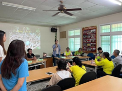
Figure 5: Changhua Coastal Wetland Conservation Wetland Seminar
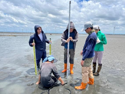
Figure 6: Hanbao Wetland Topographic Monitoring
(4) "Ecological Homelands and Urban-Rural Sustainability: A Changhua Ecological Art Project"
In response to the ecological crisis of global warming, NCUE proposed the Department of Fine Arts USR project "Ecological Homelands and Urban-Rural Sustainability: A Changhua Ecological Art Project" in 2023-2024, focusing on "local care" as the main theme to achieve the UN SDGs "13 Climate Action" goal.
(a) Starting from the university, connecting university, middle school, and elementary school teaching venues, collaborating with Changhua Industrial High School's interdisciplinary teacher community "Four Seasons Elegance: Dialogue between Herbal Tea and Solar Terms," Changhua Arts High School's "My Home Also Has a Small Forest - Horticultural Therapy Workshop," and assisting Nanguo Elementary School in organizing "Campus Green Survey" ecological teaching through cross-school curriculum co-preparation.
(b) Planning 4 ecological lectures on "Grey-faced Buzzard and Purple Crow Butterfly Ecology" (Figure 7) and 2 hands-on experience sessions of "Grey-faced Buzzard Ecological Observation: Wool Felt Workshop" (Figure 8), establishing cross-school exchange with Providence University USR in central Taiwan and building the foundation for "ecological geography."
(c) Promoting "Street Green Survey" in the Department of Fine Arts' 2024 spring semester "Curatorial Theory and Practice" course, helping students understand the formation of urban heat island effects and further developing it into an ecological art exhibition.
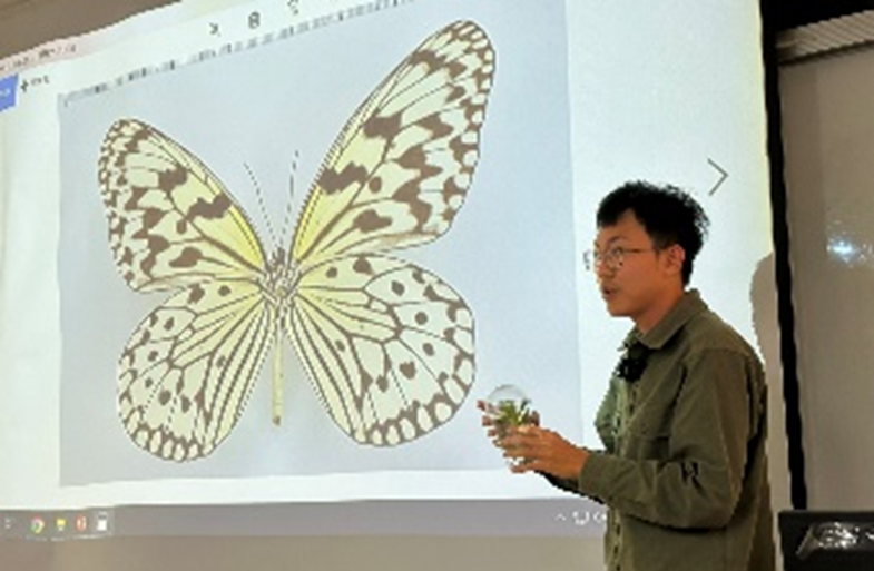
Figure 7. Ecological Lecture - Purple Crow Butterfly Introduction
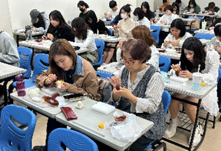
Figure 8. Grey-faced Buzzard Ecological Observation: Wool Felt Series Workshop - Three-dimensional Wool Felt Creation
(5) The "Beautiful and Treasured Clams in Fangyuan and Dacheng: Sustainable Industry and Environment Project of Changhua’s Two Cities Amid Climate Change" project
Building upon the achievements of 2023, the project focuses on assisting local governments and aquaculture industries in the Fangyuan and Dacheng areas to respond to climate change risks and promote sustainable development of industries and the environment. The team has deepened collaboration with local communities, farmers, and local associations through regular communication and consensus workshops, enabling residents and youth to jointly discuss industrial adaptation strategies and gradually build consensus on local sustainable development. The project incorporates SDG 13 and SDG 14 indicators into quantitative tracking, with strengthened investigation of potential pollution sources at water quality monitoring sites. In terms of education, course content has been expanded and youth participation in community member internships has been encouraged, with both participation numbers and knowledge enhancement effectiveness showing significant improvement compared to the previous year. Multiple community achievement sharing sessions have been organized to present water quality monitoring, industrial adaptation recommendations, and ecological education promotion effectiveness, enhancing community participation and sustainability awareness. Based on these achievements, the team plans to continue expanding community participation this year and introduce more quantitative indicators and youth empowerment programs to promote win-win development of industries and ecology in Changhua's coastal areas.
Project Activity Facebook Fan Page Link:
https://www.facebook.com/NCUEUSR/photos/?tab=album&ref=page_internal
3. Taiwan is located at the boundary of the ‘Eurasian Plate’ and the ‘Philippine Sea Plate’, so earthquakes are very frequent. According to data of the Seismological Center, Central Weather Administration, from 1991 to 2015, about 3,000 earthquakes occurred in Taiwan every month on average, and 102 major earthquake-related disasters occurred from 1901 to 2016. Although an accurate earthquake prediction technology is not available yet, increasing seismic observation data are rather helpful in improving the efficiency of disaster relief and reducing the loss of life and property during earthquakes. In cooperation with the Central Weather Administration, NCUE has installed strong motion observation apparatuses in the two campuses and in residential areas as well as the Baisha Weather station.
(1) Below are some more details about the seismic observation apparatuses (Figure 9-11).
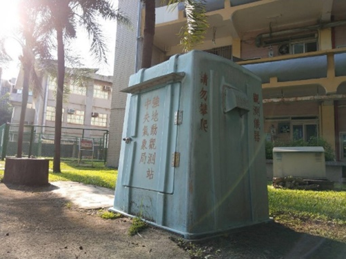
Figure 9. Strong motion observation station in Jinde Campus The observation station houses the strong motion observation apparatus. The time, location, and size of an earthquake can be calculated when many stations are connected to form a seismograph network
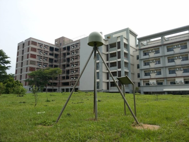
Figure 10. Crustal deformation observation station in Baoshan Campus. The station continuously receives signals emitted from the global satellite positioning system, and with the received signals at the same time by other stations, it can accurately calculate the station’s location relative to other stations. Long-term observation data could reflect significant surface displacement due to major earthquakes. Also, the data on small crustal deformation occurs during earthquakes are very helpful in understanding crustal movement and earthquake potential
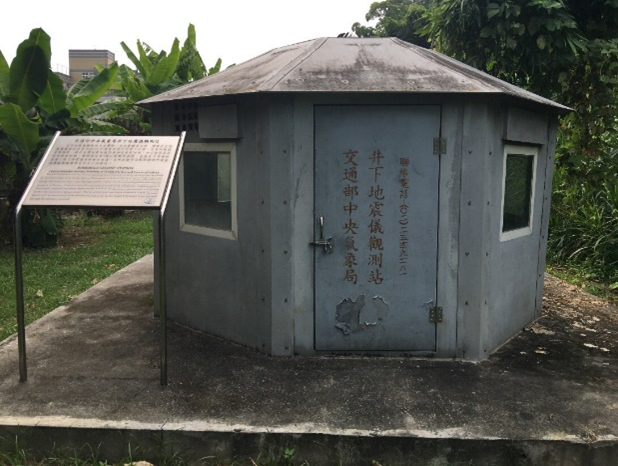
Figure 11. Underground seismograph observation station in residential areas. The seismograph installed at a depth of 300 meters in the well can significantly reduce the interference from surface noise and obtain high quality ground motion signals, improving the accuracy of seismic locating and the ability to monitor regional small-scale earthquakes
(2) The Central Weather Administration works with academic institutions in Taiwan by installing weather facilities for teaching purposes. They can be used as practice areas by students. The automatic meteorological observation station run by NCUE’s Department of Geography is one of such facilities. It is also the only station in central Taiwan under the partnership. The automatic meteorological station was built on the attic of the Geography Department Building. It was commissioned in November 1997 and has run for 27 years by 2024(Figure 12). The meteorological instruments and peripheral devices are used for real-time observation, and meteorological data are synchronized with the Southern Region Weather Center of the Central Weather Administration. The real-time data are useful for disaster prevention units. The features of the observation station are shown in the photo below. In addition, sufficiently long observation time also means that the station could help people better understand the regional climate characteristics and changes and researchers conduct relevant studies.
Related website: https://geo.ncue.edu.tw/res_02.php
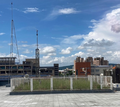
Figure 12. NCUE’s Baisha Weather Station