

|

|

|

|

|

|

|

|

|

|

|

|

|

|

|

|

|
SDG 13.3.3 Co-operative planning for climate change disasters
NCUE actively collaborates with government and related research institutions, participating in multiple climate change and disaster adaptation projects (Table 1), committed to enhancing Taiwan's response capacity when facing extreme weather and disasters through basic research, technological applications, and local participatory actions. The following presents three representative collaborative examples covering large-scale climate dynamics, coastal environmental changes, and disaster observation.
Table 1. Related National Science and Technology Council Research Projects
|
No. |
Principal Investigator |
Project Name |
|
1 |
Professor Jien-yi Tu |
Impacts of Large-scale Circulation Changes on Precipitation in the Asian Monsoon Region under Global Warming (III) |
|
2 |
Associate Professor Yi-ching Chen |
Changing Changhua Coastal Landscapes: Artificial Object-Driven Cross-Scale Spatial Development and Social-Ecological System Analysis--Multi-scale Remote Sensing Technology for Observing Changhua Coastal Topographic Changes and Environmental Control Factors (III) |
1. Impacts of Large-scale Circulation Changes on Precipitation in the Asian Monsoon Region under Global Warming (III)
(1) Government Research Information System: https://www.grb.gov.tw/search/planDetail?id=16551737
(2) Project Highlights: Research indicates that from 1979 to 2023, autumn tropical cyclone (TC) activity in the South China Sea showed significant interdecadal variations. Changes in typhoon genesis numbers are closely related to monsoon circulation anomalies, particularly low-level anticyclonic anomalies that suppress typhoon formation and movement. These research findings have high reference value for government disaster prevention and prediction system construction and help accurately predict precipitation patterns and disaster risks.
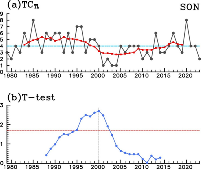
Figure 1. (a) Annual and interdecadal (9-year moving average) time series of total tropical cyclones (TC) generated in the South China Sea during autumn from 1979 to 2023. The long-term average of this time series is 4.1 (indicated by horizontal line). (b) t-values of mean difference between two interdecadal periods before and after each year from 1988 to 2014. If a year's t-statistic exceeds 1.68 (marked by horizontal line), the difference between the two interdecadal periods bounded by that year is statistically significant at the 0.05 level
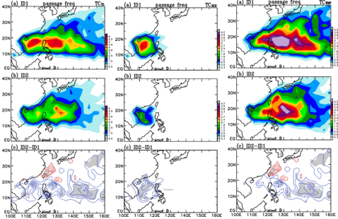
Figure 2. Mean values of autumn total tropical cyclone (TC) passage frequency: (a) ID1 (1979-1999), (b) ID2 (2000-2023), and (c) their difference (ID2-ID1). In (c), areas with statistical significance above 0.1 level are shaded. Contour intervals in (a), (b), and (c) are all 0.5. Left panel shows total passage frequency, middle panel shows typhoons generated only in the South China Sea, right panel shows typhoons generated only in the Northwest Pacific
2. Changing Changhua Coastal Landscapes: Artificial Object-Driven Cross-Scale Spatial Development and Social-Ecological System Analysis--Multi-scale Remote Sensing Technology for Observing Changhua Coastal Topographic Changes and Environmental Control Factors (III)
(1) Government Research Information System: https://www.grb.gov.tw/search/planDetail?id=16727418
(2) Project Highlights: Through satellite and drone observations from 2001 to 2023, the project reconstructed the process of Changhua tidal flat topographic changes, discovering significant north-south barrier island accumulation and identifying the impacts of artificial structures and climate events (such as typhoons) on micro-topographic changes. The research findings assist local governments in decision-making for coastal disaster prevention, land use planning, and ecological conservation strategies.

Figure 3. Construction of Changhua Coastal Tidal Flat Topographic Changes from 2001-2023
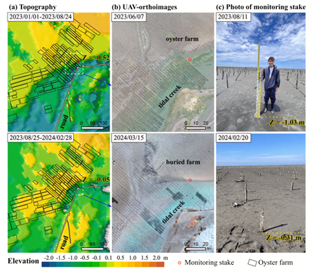
Figure 4. Impact of Hanbo Tidal Flat Topographic Changes on Oysters
3. Collaboration with the Central Weather Administration for earthquake observation and meteorological monitoring: Enhancing national disaster warning and long-term climate data construction
(1) Taiwan is located at the boundary of the ‘Eurasian Plate’ and the ‘Philippine Sea Plate’; therefore, earthquakes are frequent occurrences in Taiwan. According to data from the Seismological Center of the Central Weather Administration from 1991 to 2015, about 3,000 earthquakes occurred in Taiwan every month on average, and 102 major earthquake-related disasters occurred from 1901 to 2016.
The director of the Seismological Center stated in March 2022 that it was highly likely that the “active seismic period” has begun in the Pacific Ring of Fire, which included Taiwan.
Although an accurate earthquake prediction technology is not available yet, increasing seismic observation data are rather helpful in improving the efficiency of disaster relief and reducing the loss of life and property during earthquakes. In cooperation with the Central Weather Administration, NCUE has installed strong motion observation apparatuses on the two campuses and in the residential areas as well as the Baisha weather station.
(2) Below are some more details about the seismic observation apparatuses (Figures 5-7).
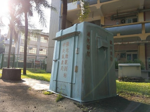
Figure 5. Strong motion observation station in Jinde Campus. The observation station houses the strong motion observation apparatus. The time, location, and size of an earthquake can be calculated when many stations are connected to form a seismograph network
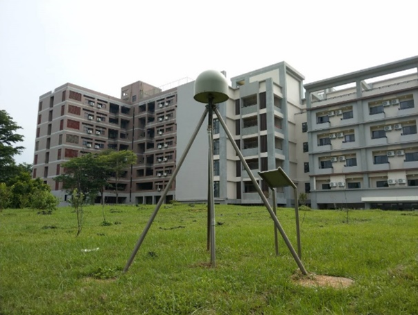
Figure 6. Crustal deformation observation station in Baoshan Campus. The station continuously receives signals emitted from the global satellite positioning system and, with the signals received simultaneously by other stations, it can accurately calculate its location relative to other stations. Long-term observation data can reflect significant surface displacement due to major earthquakes. In addition, data on small crustal deformation during earthquakes are very helpful in understanding crustal movement and earthquake potential
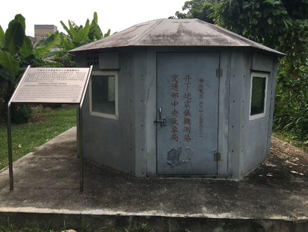
Figure 7. Underground seismograph observation station in the residential areas. The seismograph installed at a depth of 300 meters in the well can significantly reduce interference from surface noise and obtain high quality ground motion signals, improving the accuracy of seismic locating and the ability to monitor small-scale, regional earthquakes
(3) The Central Weather Administration works with academic institutions in Taiwan by installing weather facilities for teaching purposes. They can be used as practice areas by students. The automatic meteorological observation station run by NCUE’s Department of Geography is one such facility. It is also the only such station in central Taiwan under the partnership. This automatic meteorological station was built in the attic of the Geography Department Building. It was commissioned in November 1997 and will have run for 27 years in 2024 (Figure 8). The meteorological instruments and peripheral devices are used for real-time observation, and meteorological data are synchronized with the Southern Region Weather Center of the Central Weather Administration. Real-time data are useful for disaster prevention units. The features of the observation station are shown in the photo below. In addition, a sufficiently long observation time also means that the station could help researchers better understand regional climate characteristics and changes and allow them to conduct relevant studies. Related website: https://geo.ncue.edu.tw/res_02.php
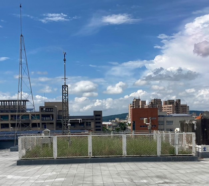
Figure 8. NCUE’s Baisha weather station
Through interdisciplinary research and multi-level government collaboration, NCUE covers scientific understanding of climate disasters, local actions, and policy impacts, effectively strengthening society's response and adaptation capacity to climate change and disaster risks, contributing concrete and substantial results to the implementation of SDG 13 "Climate Action" goals.